The outing starts at the bustling commercial strip of road at the base of Watch Hill in Westerly. This is a multifaceted place to recreate. Near at hand a visitor will find tasteful touristy shops and eateries along with some great shore exploring.
The distance along this stretch of shore is approximately one mile, one way (I came back via the lively local lanes to the car.). I parked in the large lot on the harbor side of the street, which has spaces for shoppers and yacht club patrons. The shore walk starts at the back of the parking area, along the seawall.
Next to the wall there is a pedestrian lane, clearly delineated with a white line, which extends from the parking area to the sandy paths of the Napatree sanctuary area. This dedicated public walkway is a clear example of the tremendous privileges of the coast, which we have been granted by our state constitution.
One of those rights of the shore is the freedom to walk along the edge of the water. An erroneous notion which has crept into the discussion of RI shore rights is that the public can only use the area below the high tide line. That is not the truth, and thankfully this stroll along the seawall in Watch Hill illustrates the true intent of our RI constitution.
As is the case in many other coastal locations where a seawall has been built (or where sea level has risen to meet a wall previously above the waterline) there is no place to walk between the high and low tide lines. The sea just rises and falls up and down the vertical wall. The marked walkway here in Westerly clearly guides the citizen over real estate which is most definitely above the high tide line. The RI Constitution unequivocally describes the privilege of “passing along the shore”, without mention of any restriction related to the tides!

above high tide walkway–the way it should be everywhere
At the end of the walk along the wall the explorer can choose to proceed out to Napatree Point on the bay side, or cross the peninsula to the ocean side where one can walk east or west. To get where I was going I crossed over to the ocean, and headed east towards the imposing Watch Hill headland. From the top of the dunes there is a fantastic panoramic view west encompassing Little Narragansett Bay, Napatree Point, Fishers Island, Long Island on the distant southwest horizon, and the beautiful Watch Hill lighthouse. World class!
Now came the challenging part. As I walked past the cabanas, and beach club patrons spread out on the sand, I took care to stay within ten feet or so of the water where our legal rights allow us to be. Ahead it was clear that the beach, and any surface on which I could pass further to the east, came to an abrupt end at a high seawall below several large houses perched above. Sets of stairs led from the shoreline up to their level yards. It was also clear that to pass further along the shore I was going to have to go up and walk along the edge of the lawns. So I did.
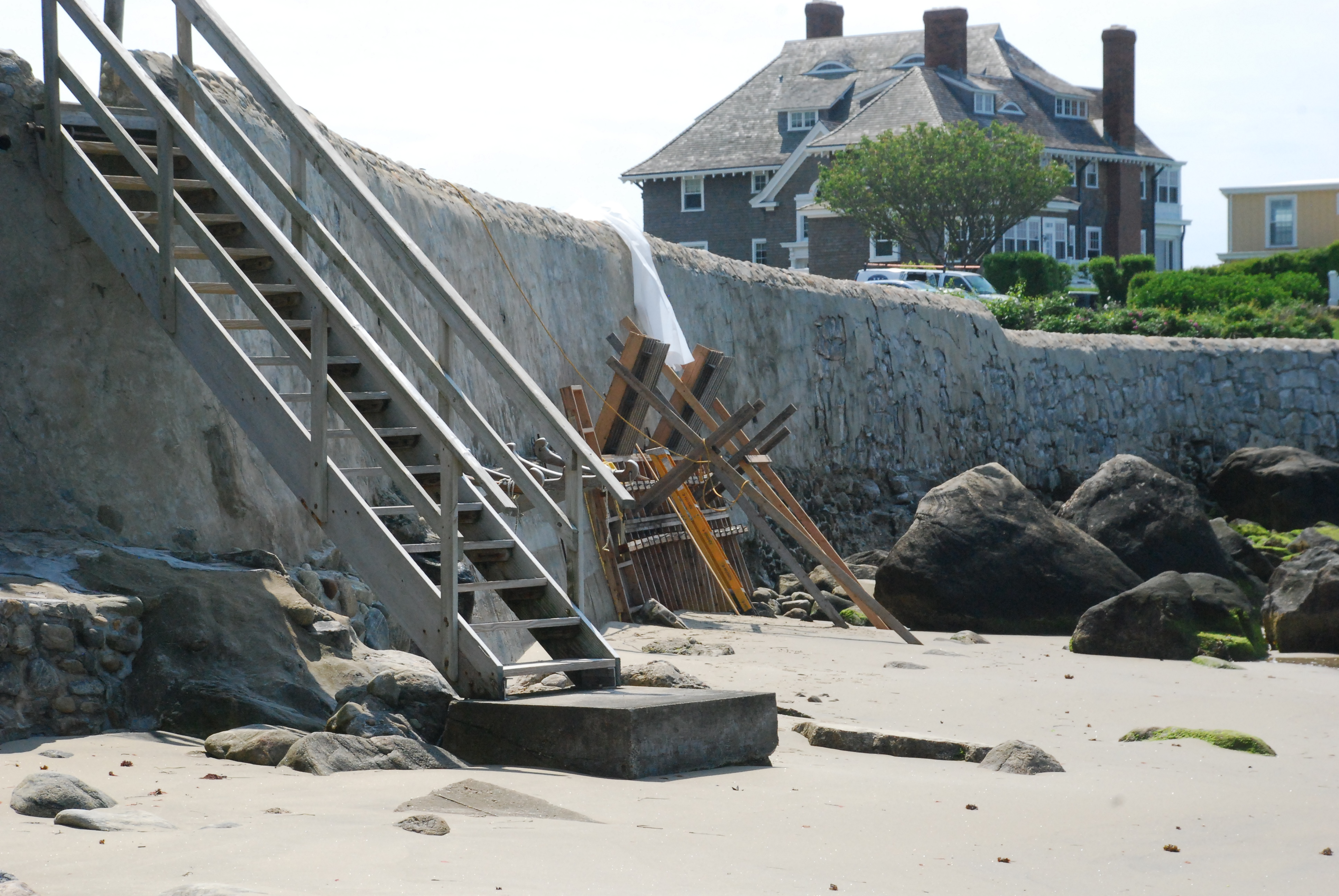
To pass along the shore the only way is up
Where does a coast walker get the right to walk up on those lawns? Why, the RI Constitution of course!
This seawall was built and backfilled to give the homes a level yard area and to protect the property from eroding and tumbling into the ocean and out of existence. As a matter of fact, on my day several sections of the wall were being repaired with new concrete and some stairs were being rebuilt. Legally protecting one’s property is certainly any homeowner’s right. There is, however, a big “BUT…” here.
That is because individual property owners cannot take away the constitutional rights of their fellow citizens under any circumstances. Build the wall; I hope it works. But when the natural coastline is altered for private benefit, it is incumbent on the property owner to plan and create a way for the public to continue to freely exercise their privileges of the shore. In effect, I made use of just that concept.
I climbed the stairs and politely strolled along the edge of the wall until I could safely drop down to (at this point) the rocky shore below. I didn’t ogle into the houses; I didn’t take pictures of the gardens…that is part of the responsibility of the shore walker, to be a respectful fellow citizen.
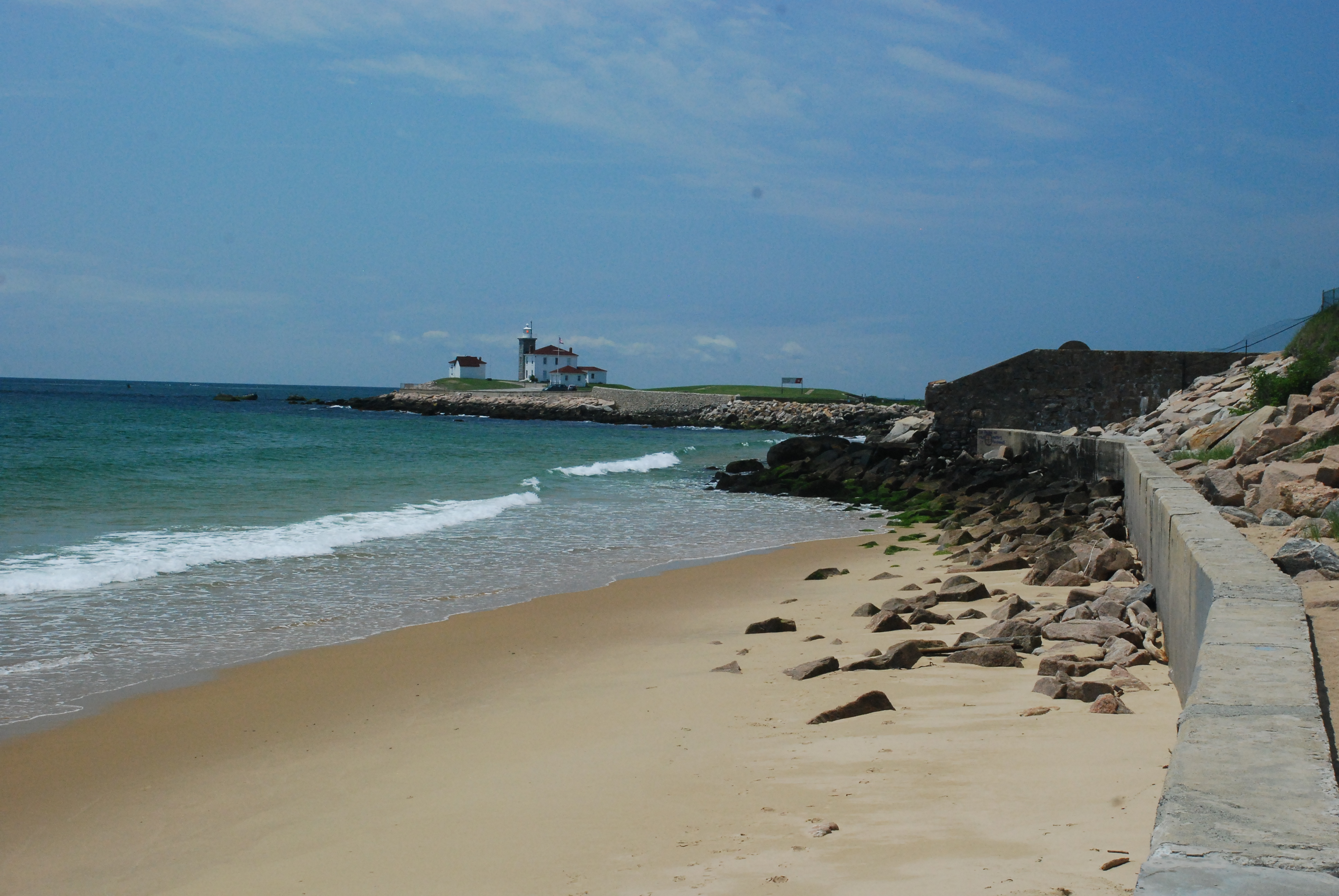
The rocks give way to a short beach section on the way towards the lighthouse, which stands on a rocky outcrop several football fields out from the mainland. It is connected and accessed by a causeway along a narrow neck of sand. A wide cement seawall runs along the road and the wall top is eminently walkable; it ends at the lighthouse grounds. On the this (west) side of this peninsula the water is relatively sheltered, with rock weed and knotted wrack draped boulders extending out some dozens of yards. On a calm day such as mine, I think this would be a premier snorkeling spot with an interesting variety of marine life to observe.
The lighthouse itself is not open to the public, but the revetment surrounding it is very pedestrian friendly. After coming down from the cement wall, and passing some pilings which must have harbored boats in the past, I passed onto massive, almost flat granite blocks which protect the lighthouse from the ocean’s energy. I assumed they were from the famous Westerly granite quarries, and they show the chisel and drill marks of hand working in times now past.
Many of the granite blocks are here, as opposed to being part of a building or monument, because they are “junk” granite. They are riddled with patches and veins of huge feldspar, quartz, and black mica crystals that render them unsuitable for architectural purposes because they weaken the rock. To a geologist like me it renders them beautiful!
-
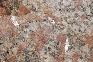
These huge crystals show their flashy side!

These wide, dry quarry blocks continue all the way around the lighthouse, and the ocean side has a 180° view encompassing Long Island and Block Island, as well as the boat traffic and the seabirds adorning the algae and guano covered rocks just offshore. This is a prime picnic or fishing spot.
Please be careful around the dark, algae covered rocks at the water’s edge. The black coating is a blue-green algae, which protects itself from drying out at low tide by incorporating a hydro-gel coating around its cells. When dry it looks walkable, but one splash from a wave and it is as slick as motor oil. Stay off of the black rocks!!
Rounding the lighthouse to the east side the view is just as grand. Extending due east in an almost straight line the south shore beaches, the jewels of Rhode Island, stretch out from your feet to Point Judith twenty miles away. From a hiker’s vantage the Point Judith Light is beyond sight, slightly below the horizon, just off of the land. It would, however, be visible from the top of the lighthouse here.
Between the fenced in lighthouse area and the mainland there are several acres of green, mowed lawn and parking areas for at least several dozen cars. It is accessible from the shopping district, by foot only, per local ordinance. Seniors and handicapped parties are allowed to drive in, however.
I had to scale a low fence to keep to the shoreline and proceed further to the east. Between the lighthouse and the beach to the east there is a fieldstone wall, and after that another seawall constructed of large boulders and quarry blocks along the shore. It was obvious from the stunted vegetation that the sea routinely washed through and over the seawall onto the sandy area behind it. On the hill above me several lovely homes were perched majestically in the sunlight against a backdrop of puffy white clouds floating in a powder blue sky.
I followed the boulder wall, walking as close to the water as I could to stay on our allowable easement along the sea. Then I encountered a true impediment to further progress. A massive stone and cement wall jutted out from the hill, ten to twenty feet tall, extending to the water with only black, dangerous rocks between it and the waves. This was not a seawall, it was a blockade. Beyond it and accessible to the public at many locations to the east, miles of beautiful sand awaited my footsteps. The only purpose this wall serves is to keep the public from passing along the shore in front of the Watch Hill properties. That is not right, and it begs the Reganesque exhortation to “tear down this wall.”
An interesting perspective on attempts like this to prevent the public from exercising their right to pass along the shore is that such actions also make the shorefront owner a prisoner of their own property lines. They too are the public to whom they are denying the freedom to walk along the water’s edge.
Wall or no wall I was out to pass along the shore, so I pressed onward. I very carefully made my way under the partly crumpled seaward terminus of the huge wall. It was not a time of high tide so there was a little room to step on the few places not covered by the black algae. At high tide or with any significant surf this move would have been even more of a problem.
Once past this obstruction the shore walker has the entire south coast of RI to explore. If one was willing and able to swim across the narrow breachways at Quonnie, Weekapaug, Charlestown, and Galilee when they got to them, he or she could literally ramble all the way to Narragansett and beyond.
This last observation is another reason to support solidifying and promoting our constitutional privileges of the shore. How many other states in our part of the country can advertise and boast that they have this unique and expansive attraction for visiting tourists? None…that’s how many! Only Rhode Island, the little state that can, offers this recreational bonanza.
On the east side of the obstructing edifice the next few houses up and out of sight on the hill have built a new cement wall along their properties at the water’s edge. Behind this is a nearly perpendicular revetment made of more large stone blocks. At the moment there is a sandy strip behind the wall, and in front of the revetment, along which one can walk with dry feet at any tide. These walls end where the low barrier beach between the ocean and the string of coastal ponds starts. This sandy pedestrian opportunity continues to the horizon. At this location there is a foot path connecting the beach to the road up on the top of the hill.
Below Taylor Swift’s house-now rebuilt, and private guards prevent us from passing along the shore.
Large signs at both the beach and the street ends of the path proclaim, “Welcome to East Beach. You are entering one of the most beautiful beaches on the east coast.” The beach is fantastic, but there is a catch.
You can only get there from here. This access point and several others further to the east have no parking from which a person could get to the beach. Furthermore, there are municipal guards who insure that cars don’t even stop to let people off to go to the beach at these walkways.
I was puzzled. These are marked and registered Rhode Island Rights of Way to the Sea, yet it seems the town of Westerly has created regulations to, and paid the cost of, preventing anyone but the people from this one neighborhood from using the shoreline here!
I left the coast here and climbed up the hill to the local street. On the way back to my starting point I passed the opening to the drive which leads to the lighthouse property. It is marked with a large red sign, allowing foot access to all and vehicular entry for those of limited ambulatory ability. Again I was puzzled.
There is paved parking at the lighthouse for dozens of cars at least, and acres of picnic room. Why not let all the public drive to the shore at the lighthouse? This question and others like it deserve a place in future public debate.
As I strode down the hill to the touristy section the uplifting scenic magic was irresistible. The view of the harbor with its fleet of boats bobbing at their moorings, the white dunes of Napatree Point stretching west towards Fisher’s Island on the horizon, and the warm smiles and cheerful chatter of people having fun at the coast put a glide in my stride and a grin on my face all the way to the car.
See you at the shore.
P.S. Check out the new website [www.rishoreaccess.org] for more information on RI shore issues and legislative initiatives.
This column is the opinion of the author. Jim Bedell is a geologist and teacher of Marine Environmental Science, biology and physics who believes that the constitutional rights of Rhode Islanders to explore the state’s shore are being threatened. He welcomes comments or questions from readers seeking more background on public access rights or any coastal issues. He can be reached by calling 401-499-1405 or e-mailing jimbedell@cox.net.